|
Glass and a Gut
Sat. 25th Aug., 2001
|
 |
|
|
|
Lemington is 7 km (4¼ miles) west of the city centre, and the first mention of the place is in records of the
16th century listing Laman Mill.
In 1876 the railway arrived to this small riverside village, and at the same time
the curved course of the river was by-passed by a wide channel past Blaydon. The old course was dammed at one end and the backwater created was called "The Gut". For many years dredgers kept the silt
at bay so that coal and other produce could be moved by boat from Lemington Point. This was also the starting point for many skiff races |
|
|
|
|
|
|
|
|
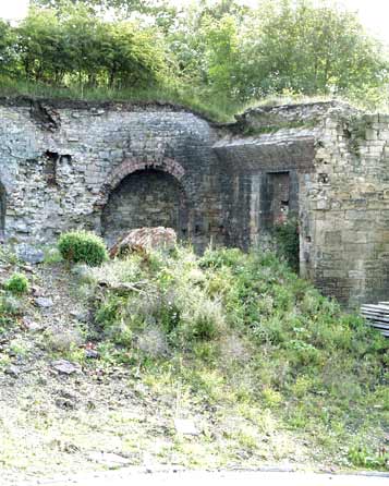
An iron foundry worked here from 1797 until 1886 and the remains of the coke ovens still exist near the little
industrial estate next to the Gut. An electricity generating station was erected in the ruins in 1903 and from 1919 until its demolition in 1946 it provided power for the tramway system in the west of the
city.
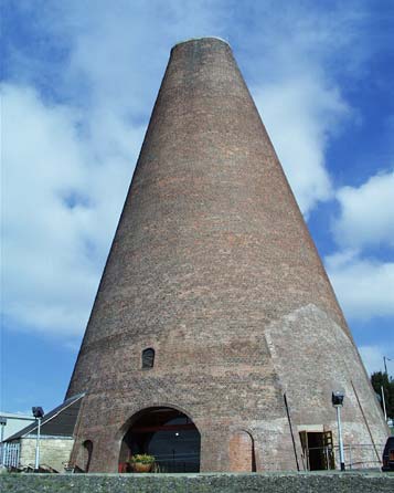
The Northumberland Glass Company set up their factory here in 1787 and the famous brick cone dated from this time. Glass production ceased some years ago, but it is still owned by GB Glass
Bulbs Ltd. and is now a museum of glass production here.
After the arrival of the railway the village was extended up the steep Tyne bank on the northern side of the tracks. |
|
|
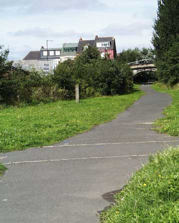
Here the old rail tracks have been filled in, they were removed with the closure of the Ever Ready battery factory
in Newburn in 1992.
The station closed many years before that in the 1940s. Until only a few short years ago the Station Hotel stood here, opposite the junction with Union Hall Road that leads up the
almost impossible gradient to the West Road.
To the left is the path leading to the glassworks and once a pub called The Tyne Iron, but known locally as the Hairy Man. A new road, built in the 1930s
now by-passes the village and lies to the left of here, between the rail bed and the glassworks. |
|
 |
|
|
|
©1993 Geoff Philips |
|
|
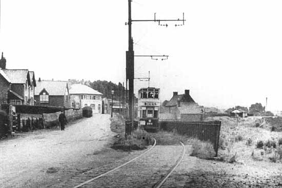
Here is the view in 1921. The roadway is High Row, the railway is just to the left of those houses, and the light building at
the end is The New Tyne Iron; the business moved up the hill from the industrial Gut area, but the original building remained, and parts can still be seen today. Below is the same view today. The reserved tram track has
been absorbed into the new roadway, The New Tyne Iron building is now commercial offices, and a working men's club has been and gone in the meantime. |
|
 |
 |
|
|
|
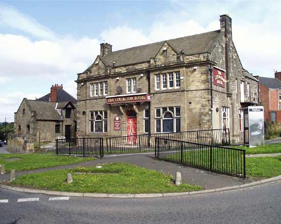
To the west of High Row stands The Lemington Hotel, built in 1897. It is presently disused and subject to vandalism. The
stables can be seen just beyond the main building. The old road, Northumberland Road, runs to the right and over the rail bridge to Tyne view. The Duke of Northumberland owned this, several other
 businesses, and some land here, gradually selling his
interests from 1906 until the mid 1930s. businesses, and some land here, gradually selling his
interests from 1906 until the mid 1930s.
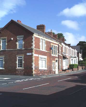
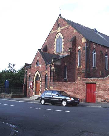
The Primitive Methodist chapel was built in 1891 slightly uphill from the Hotel. It is on Algernon Road in the new development ushered in by the arrival of the railway.
Houses, shops, and a Workers' Institute went up during this late Victorian and Edwardian building boom.
Some older slums near the river were swept away and the industry and the housing became
separated. I fancy this was not through some good will on the part of the industrialists, but was born of their wish to develop the industrial land to generate more profit. |
 |
|
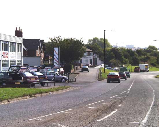
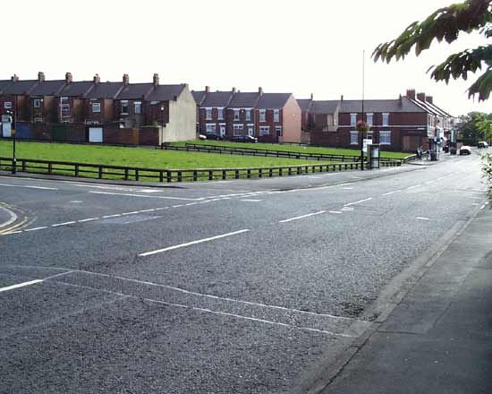
Along Tyne View this void marks the space previously occupied by a large Co-op store, and beyond that a telephone exchange. The
Co-op was split into various departments. There was a butchery, a grocer, a draper, a furnishing department, and latterly a laundrette and dry cleaning shop. During the 1970s it was let out to other shop owners as
 the Co-op declined and the
building lay empty for a couple of years before being demolished in 1989. There are plans to turn this plot into a local leisure resource. Union Hall Road, named from a long gone meeting place for workers, runs
to the left from this junction. the Co-op declined and the
building lay empty for a couple of years before being demolished in 1989. There are plans to turn this plot into a local leisure resource. Union Hall Road, named from a long gone meeting place for workers, runs
to the left from this junction.
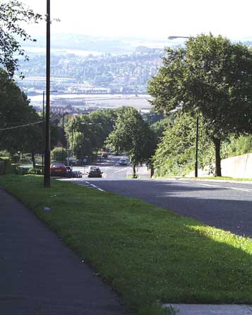
Seen from the top of the hill, the steep bank is apparent. Beyond the trees and houses the river curves around past Blaydon on the opposite bank. This is the
new channel that was built in 1876, and the flat island so formed now stands idle. This area was called "Canary Island" during World War One, because of the discolouration of the worker's skin at the cordite
works there. Later graphite rods for nuclear power stations were built there. |
 |
|
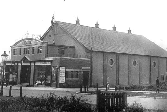
©1991 Newcastle Chronicle & Journal |
|
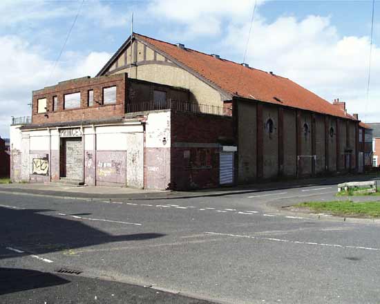
This is the Prince of Wales in Rokeby Street, and it was in all senses a local cinema. It was designed by W. Clark from here,
built by local builders Straker, and the name was chosen by a ballot of the local people. It opened in July, 1924, and the picture above shows the finishing touches being made before opening. The films on offer were
"Sporting Youth" and "The Phantom Fortune".
It flourished as a film and vaudeville venue, being built to a stadium plan with a stage and orchestra pit. The local Amateur Operatic Society staged yearly
spectaculars here, including Gilbert & Sullivan. In 1956 the wide screen Cinemascope system was installed, but the decline in audiences led to its closure in 1960. It was used as a bingo hall for a little over
twenty years before being bricked shut to await further bright ideas for its use. Today's view shows it a little sadder, but substantially unchanged from its opening day. |
|
 |
|
|
|
|
|
Now for two contrasting housing types. This is the junction of Union Hall Road and Eva Street. These grand
Edwardian houses made stout homes for the middle classes on the corner property, and the more lowly workers in the smaller flats around. A grand double fronted dwelling is just visible at the end of the
terrace.
Beyond that, behind those trees stands "Hillside" a grand stone pile erected for an industrialist in its secluded and leafy grounds. It became the residence of the local doctor and passed
into more public use as a surgery and health centre from the early 1970s. |
|
|
|
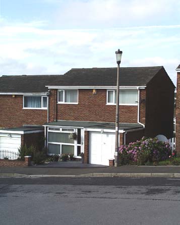
Further up the hill, adjacent to the cemetery, is a now mature modern housing estate. These linked semi-detached
dwellings were built by Barratt in 1973 just in time for a slump in the housing market!.
I was the first occupant of this particular house, moving on during late 1977. Building has proceeded apace
since then and these are now the older, and more substantial, examples of modern housing.
The local hospital, originally an isolation unit for infectious diseases, has recently been purchased for
demolition and redevelopment.
Lemington remains a community; its residents consider themselves special and somewhat separate from the Newcastle mainstream. |
|
|
|
|
|
Site and contents (unless otherwise stated) © Tim. Pickford-Jones and Timmonet, Newcastle upon Tyne,
United Kingdom. |
|
|
|
|
 |
|
If you should arrive here via a search, or be missing the navigation on the left hand side, click this button.
|
|